mapbox-gl-rain-layer
v0.7.0
Published
Mapbox GL Rain Layer
Downloads
527
Readme
Mapbox GL JS Rain Layer
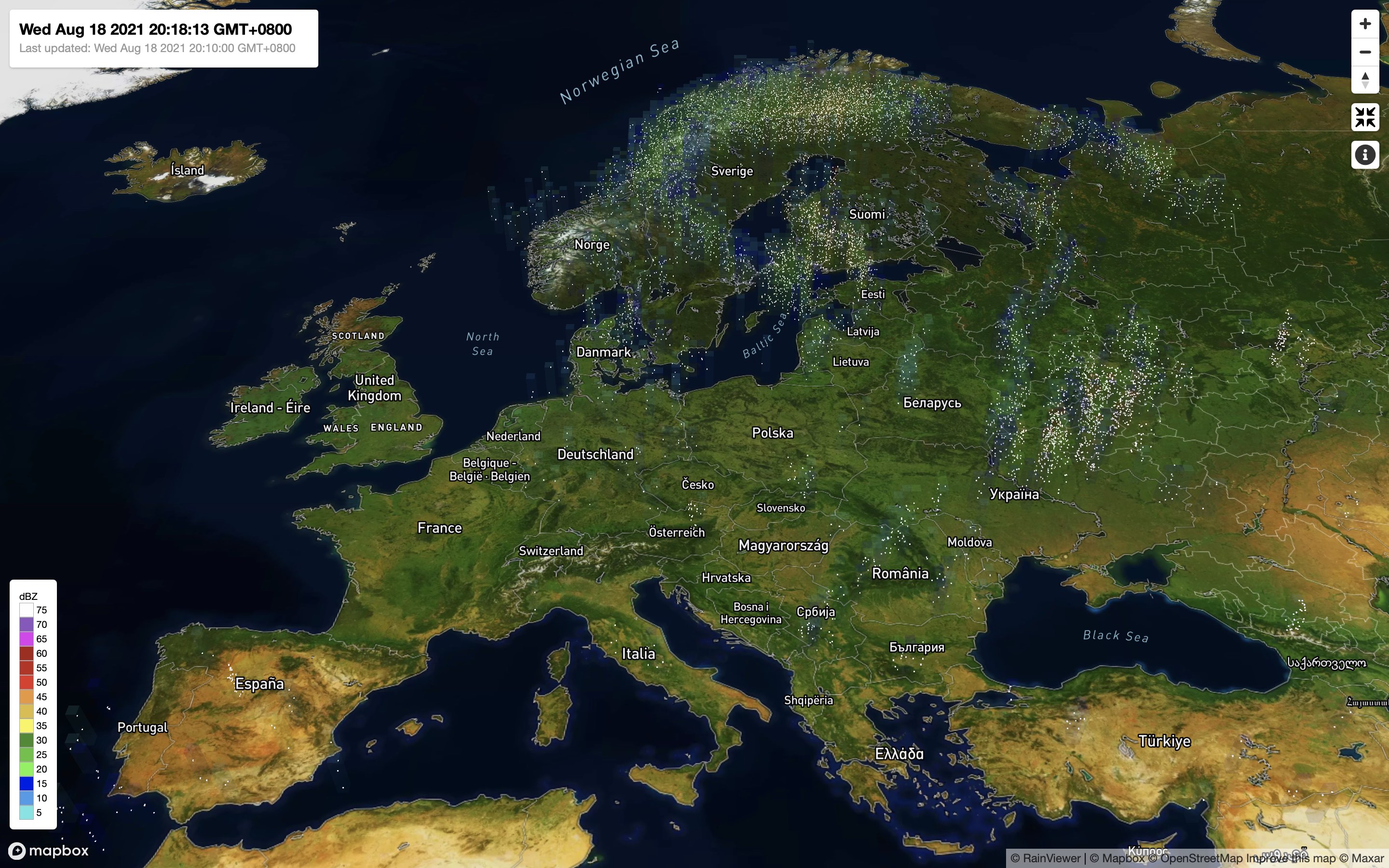
An animated rain layer for Mapbox GL JS

See a Live Demo.
The rain animation is up to date according to the current radar data from data sources. In addition to the density of raindrops, the colors of semi-transparent boxes indicate the intensity of rainfall.
Version 0.7 requires Mapbox GL JS 0.54.0 or later, and only works with the Mercator projection. This component works on browsers that support ES6. It supports the Mapbox Standard style but only works at zoom level 6 or above.
Installation
You can download the latest version of Mapbox GL JS Rain Layer from the GitHub releases.
To install via npm:
npm install mapbox-gl-rain-layer --saveTo use CDN:
<script src="https://cdn.jsdelivr.net/npm/mapbox-gl-rain-layer@latest/dist/mapbox-gl-rain-layer.min.js"></script>Usage
Mapbox GL JS Rain Layer can be used with ES6 modules, plain JavaScript and module loaders.
Mapbox GL JS Rain Layer requires Mapbox GL JS. Include Mapbox GL JS and Mapbox GL JS Rain Layer to your page, then you can use the RainLayer class, which can be added to your map as a layer.
const rainLayer = new RainLayer({
    id: 'rain',
    source: 'rainviewer',
    scale: 'noaa'
});
map.addLayer(rainLayer);

// You can get the HTML text for the legend
const legendHTML = rainLayer.getLegendHTML();

// You can receive radar data refresh events
// data.timestamp - Unix timestamp in seconds (UTC) when the data was generated
rainLayer.on('refresh', data => {
    console.log(data.timestamp);
});
Usage in ES6 as module
Import the module as RainLayer, and use it in the same way as described above.
import RainLayer from 'mapbox-gl-rain-layer';Samples
You can find an interactive demo at nagix.github.io/mapbox-gl-rain-layer.
API
Constructor Options
RainLayer supports the following constructor options.
| Name | Type | Default | Description
| ---- | ---- | ------- | -----------
| options.id | string | | A unique identifier that you define.
| options.maxzoom | number | | The maximum zoom level for the layer. At zoom levels equal to or greater than the maxzoom, the layer will be hidden. The value can be any number between 0 and 24 (inclusive). If no maxzoom is provided, the layer will be visible at all zoom levels for which there are tiles available.
| options.meshOpacity | number | 0.1 | The opacity of mesh boxes. The value can be any number between 0 and 1 (inclusive).
| options.minzoom | number | | The minimum zoom level for the layer. At zoom levels less than the minzoom, the layer will be hidden. The value can be any number between 0 and 24 (inclusive). If no minzoom is provided, the layer will be visible at all zoom levels for which there are tiles available.
| options.rainColor | string | '#ccf' | The color of raindrops. Colors are strings in a variety of permitted formats: HTML-style hex values, RGB, RGBA, HSL and HSLA. Predefined HTML colors names, like yellow and blue, are also permitted. The default is light blue.
| options.slot | string | | (Optional) The identifier of a slot layer that will be used to position this layer.
| options.snowColor | string | '#fff' | The color of snowflakes. Colors are strings in a variety of permitted formats: HTML-style hex values, RGB, RGBA, HSL and HSLA. Predefined HTML colors names, like yellow and blue, are also permitted. The default is white.
| options.repaint | boolean | true | If true, rendering is automatically triggered for every frame. If false, Map#triggerRepaint() needs to be called explicitly.
| options.scale | string | 'noaa' | The type of the color scale for the radar/precipitation data. Currently, only 'noaa' is supported. See Radar Images: Reflectivity by National Weather Service for details.
| options.source | string | 'rainviewer' | The data source for the layer. Currently, only 'rainviewer' is supported.
Instance Members
getLegendHTML()
Returns the HTML text for the legend.
Returns
string: The HTML text for the legend.
off(type, listener)
Removes an event listener previously added with RainLayer#on.
Parameters
type (string) The event type previously used to install the listener.
listener (function) The function previously installed as a listener.
Returns
RainLayer: this
on(type, listener)
Adds a listener for events of a specified type.
Parameters
type (string) The event type to listen for.
listener (function) The function to be called when the event is fired.
Returns
RainLayer: this
once(type, listener)
Adds a listener that will be called only once to a specified event type.
Parameters
type (string) The event type to add a listener for.
listener (function) The function to be called when the event is fired.
Returns
RainLayer: this
setMeshOpacity(opacity)
Sets the opacity of mesh boxes.
Parameters
opacity (number) The opacity of mesh boxes. The value can be any number between 0 and 1 (inclusive).
Returns
RainLayer: this
setRainColor(color)
Sets the color of raindrops.
Parameters
color (string) The color of raindrops. Colors are strings in a variety of permitted formats: HTML-style hex values, RGB, RGBA, HSL and HSLA. Predefined HTML colors names, like yellow and blue, are also permitted.
Returns
RainLayer: this
setSnowColor(color)
Sets the color of snowflakes.
Parameters
color (string) The color of snowflakes. Colors are strings in a variety of permitted formats: HTML-style hex values, RGB, RGBA, HSL and HSLA. Predefined HTML colors names, like yellow and blue, are also permitted.
Returns
RainLayer: this
Events
refresh
Fired when the radar data is refreshed.
Properties
timestamp (number): Unix timestamp in seconds (UTC) when the data was generated
Building
You first need to install node dependencies (requires Node.js):
npm installThe following commands will then be available from the repository root:
npm run build    # build dist files
npm run lint     # perform code linting
About Data
The data for this visualization are sourced from RainViewer, which also gathers data from different data sources.
License
Mapbox GL JS Rain Layer is available under the MIT license.
